Steve

Membru din 11.09.2014, 0 abonati

Logheaza-te pentru a te putea abona sau trimite mesaj privat.

Nu ai cont? Creeaza-ti cont.

Activitate
Originalitate:
98.86%
Prezentari: 176 prezentari
Prezentari proprii: 174 prezentari
Alte prezentari: 2 prezentari
Comentarii: 17 comentarii

Steve - 173 prezentari proprii

Malaysia - Asia's Wonderland - Tomy,Steve

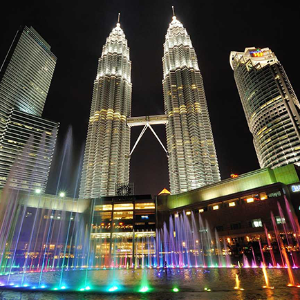
Malaysia is a country in Southeast Asia that occupies most of the Malaysian Peninsula and the northern part of Borneo. It has an area of 330,803 km2. It consists of thirteen states and three federal territories. The country is multiethnic and multicultural. About half of the population is ethnically Malaysian, with large minorities of Malaysian Chinese, Malaysian Indians and indigenous peoples. The capital Kuala Lumpur has many colonial buildings, busy shopping districts and skyscrapers, such as [...]

Vizualizari: 871 in total, 0 pe zi (in medie)

Descarcari: 186 in total

Meandering Rivers - Tony,Steve

Meander is the deviation of the watercourse from the straight direction in the form of an arc. The name derives from the name of the Maiandros River (now Menderes) in Turkey. They arise from lateral erosion of watercourses. The impact bank is washed away by the watercourse and the opposite bank is the place where river sediments settle. Meanders are divided into loose (formed in large flat sections) and deepened (formed where the rivers cut through the mountains). [...]

Vizualizari: 1146 in total, 0 pe zi (in medie)

Descarcari: 140 in total

Metamorphosis - Steve

Revúca is a district town with more than 11,000 inhabitants. The town is located in the Central Slovakia in the Slovak Ore Mountains at the level of 318 m over the sea. The earliest written record of the town is from 1427. For more than 500 years was Revúca the center of the iron industry. In the second half of the 20th century developed in the magnesite industry. During the second half of the 19th century Revúca became a center of the Slovak national revival. The first high school teaching i [...]

Vizualizari: 401 in total, 0 pe zi (in medie)

Descarcari: 56 in total

Mexico (Aguascalientes) - Steve

I am sending the first of several presentations representing different regions of Mexico. They were made from photos and with music selected by my friend Lalo. I hope the they will be interesting for you. I will send my other finished presentations as soon as possible. Have a beautiful day. Steve [...]

Vizualizari: 1176 in total, 0 pe zi (in medie)

Descarcari: 170 in total

Mexico (The Huastecos) - Lalo,Steve

The Huasteca civilization was born when groups of Mayans migrated to the Pánuco region and settled in the north of the Gulf Coast. The Huasteco people did not disappear with the Spanish Conquest; their descendants continue to live in the region that their ancestors historically inhabited. The Huastecs have inherited beautiful works of art in which the Feathered Serpent and the snail, which is the symbol of the Spirit and of Quetzalcóatl, appear repeatedly. You can find the video version of my [...]

Vizualizari: 880 in total, 0 pe zi (in medie)

Descarcari: 93 in total

Mexico (this is Baja California Sur) - Lalo, Steve

Video versions of my presentations are stored at: https://www.youtube.com/channel/UC4x4T-5Itm_FsR07hKJYstA/videos Baja California Sur is a Mexican state located in the southern part of the California Peninsula. The capital is La Paz, located in the southern part of the peninsula. The relief is characterized by coastal plains, a mountainous California system and two deserts: the Central Desert and the Vizcaín Desert. The highest peak is the Sierra de la Laguna with an altitude of 2,080 meters. [...]

Vizualizari: 776 in total, 0 pe zi (in medie)

Descarcari: 132 in total

Mexico (this is Baja California) - Lalo, Steve

Baja California is a federal state of Mexico located in the north of the California Peninsula. In the north it borders on the USA (California and Arizona). The surface is full of contrasts. There are mountains, valleys and deserts. The mountain system runs along the entire length of the state. The highest mountains are Sierra Juárez (1,800 m) and San Pedro Mártir (3,100 m). Three quarters of the surface is the Desierto Sonorense desert. Baja California is not rich in water. 88 % of water resou [...]

Vizualizari: 958 in total, 0 pe zi (in medie)

Descarcari: 108 in total

Mexico (this is Campeche) - Lalo, Steve

Campeche is a Mexican state located partly on the Yucatan Peninsula on the Gulf Coast. It has an area of 57,507 km² and a population of 849,617, half of whom live in the capital - Campeche. Until XVI. century this area was inhabited by the Maya peoples. Their seat Edzná is the most important archaeological site. The surface of the state is lowland, largely covered with forest. The country has a hot and humid climate. The large amount of precipitation affects the amount of rivers and lakes. The [...]

Vizualizari: 796 in total, 0 pe zi (in medie)

Descarcari: 128 in total

Mexico (this is Chiapas 1) - Lalo, Steve

The Mexican state of Chiapas, with a population of over 5 million, is located in the southeastern part of Mexico. Most of its population is native Indians. The capital is Tuxtla Gutiérrez. The Mayan ruins of Palenque, Yaxchilán and others are located here. In general, Chiapas has a humid, tropical climate. but the climate is tempered in many areas by altitude. Mountain areas affect wind flow and humidity, thus concentrating humidity in certain areas. This creates the conditions for the formati [...]

Vizualizari: 754 in total, 0 pe zi (in medie)

Descarcari: 57 in total

Mexico (this is Chihuahua 1) - Lalo, Steve

Chihuahua, the largest state in Mexico, is located in its northwestern part. It is characterized by rugged mountainous terrain and wide valleys. Dominant is Siera Madre Occidental with the biggest attraction of the state - Las Barrancas del Cobre. It is a magnificent system of canyons, larger and deeper than the Grand Canyon. In the mountainous part of the state there are two national parks - Cumbres de Majalca National Park and Basaseachic Falls National Park. There are also the two largest wat [...]

Vizualizari: 749 in total, 0 pe zi (in medie)

Descarcari: 53 in total

Mexico (this is Colima) - Lalo, Steve

Colima is a small state of Western Mexico on the central Pacific coast. The state is in an offshoot of the Sierra Madre Occidental mountain range and geographically consists of four mountain systems. Three quarters of the state is covered by mountains and hills. At the very north of the state, the border is marked by two volcanoes. The Colima Volcano, also called the Volcán de Fuego, is active. The main river of the state is the Cihuatlán. The state has one of the highest standards of living i [...]

Vizualizari: 358 in total, 1 pe zi (in medie)

Descarcari: 42 in total

Mexico (this is Guerrero) - Lalo, Steve

Guerrero is a federal state in Mexico. It is located in the southern part of the country on the Pacific coast. Its territory can be divided into three main parts. The northwestern region is Tierra Caliente. To the south is the coast La Costa and the rest is mostly forested mountains La Montaña. The coastal area is composed of two parts - the Costa Grande to the west of Acapulco and the Costa Chica to the east. The most famous tourist destination of the state is Acapulco on the coast. However, Z [...]

Vizualizari: 750 in total, 0 pe zi (in medie)

Descarcari: 73 in total

Mexico (this is Morelos) - Lalo, Steve

Morelos is a landlocked country located in the southern part of central Mexico and has an area of 4,893 km2. It is the second smallest state with about 2 million inhabitants. Its capital is Cuernavaca, located just 90 km south of Mexico City. Due to its pleasant climate, it is also called the "City of Eternal Spring". Morelos, whose territory lies mainly at an altitude of 1000 - 3300 meters above sea level, has a very diverse topography. The climate and vegetation varies from alpine meadows at t [...]

Vizualizari: 851 in total, 0 pe zi (in medie)

Descarcari: 112 in total

Mexico (this is Nayarit 1) - Lalo, Steve

The state of Nayarit is located in northwestern Mexico on the Pacific coast and includes the islands of Tres Marías. The area of the state is almost 28,000 km² and the population is 1.3 million. The capital is Tepic. The average annual temperature is 24 °C. Rainfall occurs mainly in summer in the months of May to September. Vegetation is diverse and depends on the prevailing climate and soil factors in the region. The tourist attraction of the state of Nayarit is its Pacific coast. The Nayari [...]

Vizualizari: 762 in total, 0 pe zi (in medie)

Descarcari: 79 in total

Mexico (this is Quintana Roo) - Lalo, Steve

The Mexican state Quintana Roo is located in the east of the Yucatan Peninsula. It has more than 1.5 million inhabitants. The capital is Chetumal, but the largest city is Cancun. The north of the state is washed by the waters of the Gulf of Mexico, the east coast touches the Caribbean Sea. The state coast is bordered by the second largest coral reef on earth - the Mesoamerican coral reef. Most of the Yucatan Peninsula is formed by a large limestone karst plate. The highest point is at an altitud [...]

Vizualizari: 983 in total, 0 pe zi (in medie)

Descarcari: 100 in total

Mexico (this is Sinaloa) - Lalo, Steve

Sinaloa is a federal state in northwestern Mexico on the coast of the Gulf of California. It covers an area of 58,328 km2 and has a population of approximately 3.2 million. The capital is Culiacán Rosales. Other important cities are Mazatlán and Los Mochis. The relief of the state of Sinaloa is divided into two large areas - the Sierra Madre Occidental and the Pacific coastal plain. It is rich in rivers, the most famous of which are Culiacán, Fuerte and Sinaloa. The state's climate ranges fro [...]

Vizualizari: 593 in total, 0 pe zi (in medie)

Descarcari: 90 in total

Morocco (Marrakech) - Steve

The video is at: https://www.youtube.com/@steverumpler Marrakesh is one of the four imperial cities of Morocco. It is located west of the foothills of the Atlas Mountains, 240 km south of Casablanca. The region has been inhabited by Berber farmers since the Neolithic. The city was founded in 1070 by Emir Abu Bakr ibn Umar as the imperial capital of the Almoravid Empire. The city's red walls built by Ali ibn Yusuf in the 12th century and other buildings built later from red sandstone gave the ci [...]

Vizualizari: 837 in total, 1 pe zi (in medie)

Descarcari: 80 in total

Myanmar

Myanmar (former Burma) is a sovereign state in Southeast Asia bordered by Bangladesh, India, China, Laos, Thailand and the Indian Ocean. Myanmar is 678.000 km² in size and has about 50 million of people. The country’s capital city is Nay Pyi Taw. Myanmar produces precious stones as jade, rubies and sapphires, oil, natural gas and other mineral resources. The first Burmese state was the Pagan Kingdom. In 11th and 13th century spread over the most surface of the actual Myanmar territory. After repeated Mongol invasions in the 13th century, the kingdom collapsed and the fragmented country was reunified in 17th century. Myanmar has wet and warm climate passing into subtropical in the North of the country. It lies in the monsoon region of Asia. Almost the half of the region is covered by rain forests.

Vizualizari: 2273 in total, 0 pe zi (in medie)

Descarcari: 421 in total

Myanmar (on the road) - Steve

Myanmar (also known as Burma) is a country in Southeast Asia. It has a total area of 678,500 km2 and its population is approximately 54 million (2017). Most residents live in the Irrawaddy Valley. The country is very ethnically diverse. The government recognizes 135 ethnic groups. Myanmar was an English colony in the period (1824–1948). Its capital is Naypyidaw. The largest and former capital is Yangon (Rangoon). Much of the country lies in the Monsoon Zone. The main agricultural product is ri [...]

Vizualizari: 625 in total, 0 pe zi (in medie)

Descarcari: 100 in total

New Zealand (Abel Tasman National Park) - Steve

Abel Tasman National Park is New Zealand's smallest national park, located between Golden Bay and Tasman Bay at the northern end of the South Island. Its area is 237 km2. The park was opened in 1942. It is named after Abel Tasman, who in 1642, as the first European explorer to sight New Zealand. The park consists of a forested hilly country north of the valleys of the Takaka and Riwaka rivers. It is bounded to the north by the waters of Golden Bay and Tasman Bay. It contains some of the islands [...]

Vizualizari: 722 in total, 0 pe zi (in medie)

Descarcari: 116 in total